
Water in Texas

Water has been a cherished, regulated resource in Texas since the San Antonio area was first settled by the Spanish. Spanish law determined that the rights to surface water from creeks, rivers, and lakes belonged to the landowners adjacent to a body of water; landowners were riparian and had the right to determine how that water was used.
The climate and geography of Texas present government with more than a water management challenge. The endless cycle of relentless drought and devastating flood sets Texas apart and creates unique issues for law and public policy.Water law in Texas began early in Texas history, when the San Antonio area was first settled by the Spanish. Spanish law determined that the rights to surface water from creeks, rivers, and lakes were riparian: that is, the landowners adjacent to a body of water had the right to determine how that water was used. This doctrine remained essentially unchanged even after Texas independence and statehood. However, the Texas Supreme Court noted as early as 1872 that riparian doctrine was unsuitable as settlement moved into the arid regions of West Texas and the Panhandle.
Beginning in the 1890s, Texas began to implement a legal doctrine known as prior appropriation. Simply put, prior appropriation means that the state issues water rights for surface water with multiple stakeholders. Rights may be assigned according to seniority among the permit holders, or allocated according to a complex formula between residential, industrial, and agricultural users. In 1913, the legislature created the Texas Water Commission (now the Texas Commission on Environmental Quality) to oversee water appropriations. Prior appropriation was implemented incrementally over many decades, and conflicts between permit holders and those with existing riparian rights were a source of numerous court cases well into the 1980s.
The legal complexities add to the challenge of managing this resource necessary for life and commerce, especially in times of extreme scarcity, when the water rights allocated to a particular stream exceed the amount of water available.
Falcon Lake

Old Guerrero being submerged during the filling of Falcon Lake, 1954; Old Guerrero in 1950, prior to the creation of Falcon Lake; The landmark chapel Nuestra Señora Del Refugio reemerging from Falcon Lake, undated. Guerrero Viejo photo notebook, Texas Historical Commission Records.
Falcon International Reservoir (commonly known as Falcon Lake) is a massive lake created by damming the Rio Grande between Laredo, Texas, and Nuevo Laredo, Mexico. These photos tell the story of the flooding of Old Guerrero as well as its reemergence beginning in the 1990s, when drought and increased demand for water downstream led to falling levels at Falcon Lake.
Due to ongoing violence between rival drug cartels, travelers are advised to use extreme caution if traveling to the Falcon Lake area at this time. All photos: Guerrero Viejo photo notebook, Texas Historical Commission Records.
Orange Floods
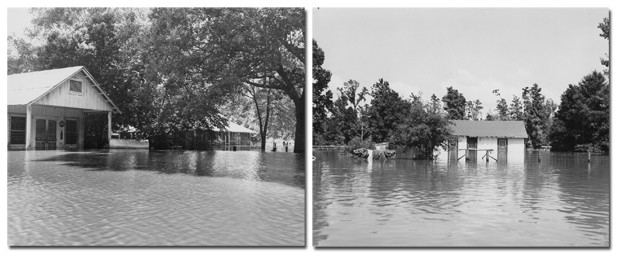
Catastrophic flooding near Orange and Deweyville in East Texas, 1953. Prints and Photographs Collection.
Mansfield Dam

Construction of Marshall Ford (now Mansfield) Dam on the Colorado River, circa 1940, then in 1955 with the floodgates open.
Buchel Dam

This 1899 photograph shows Buchel Dam on the Guadalupe River north of Cuero, Texas. The dam was only the second hydroelectric dam constructed in Texas and was constructed to furnish power and irrigation for three rice farms. The dam and the powerhouse shown on the right burned in 1908. Prints and Photographs Collection.
Buchanan Dam

View of Buchanan Dam, 1968. Completed in 1938, Buchanan Dam is an architectural rarity. At two miles it is the longest multi-arch dam in the nation. The dam was the first completed of the seven massive Highland Lakes dams, which “tamed” the Colorado River for the purposes of flood control and irrigation. Prints and Photographs Collection.